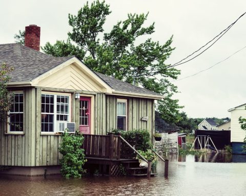
For many Toronto residents, the July 2013 floods remain a vivid memory. A storm unleashed 126 millimetres of rain on Toronto over the course of two hours. Assessments in the months after pointed the finger at the city’s aging infrastructure as much as unexpected weather irregularities.
The most visible culprits were the impermeable rooftops, roads, and sidewalks that directed runoff to the city’s gutters. Manholes erupted into geysers as Toronto’s sewers were pushed beyond capacity, flooding such well-loved parks as Christie Pits and Trinity Bellwoods. It was no coincidence that these areas were affected by heavy flooding: these locations trace the path of Garrison Creek, a waterway that was sewered in the late 1800s.
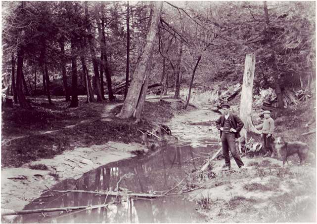
The origin story
The foundation of the creek was formed 12,000 years ago by the slow retreat of the Wisconsinan Glacier. The lack of vegetation to bind the soil together allowed early rivers such as Garrison Creek to quickly form deep ravines. Aboriginals and early Europeans hunted, fished and farmed near its banks.
Garrison Creek got its name from the military garrison Fort York, which used the waterway as a natural fortification on its eastern side. Colonel John Graves Simcoe ordered for the garrison’s construction in 1793 with the intent of establishing a naval base to protect against attacks from the United States. Soldiers also turned to the creek as a source of salmon and drinking water.
Yet the waterway’s open accessibility would later be its downfall.
Throughout the 1800s, citizens treated the creek as an open sewer. The cholera epidemics in 1832 and 1834 pushed the city to establish actual sewers to deal with wastewater, but Garrison Creek was still seen as a contributor to cholera and typhoid fever outbreaks.
City councilors and nearby residents eventually petitioned for the creek to be sewered, on the basis that it posed a public health hazard. The polluted waterway also lowered the value of the surrounding property, which limited the taxes the city could assess.
In 1884, the city council passed legislation allowing for the creek to be buried, though the decision was not without opposition. E. O. Bickford, who owned property on Garrison Creek’s path, filed a legal complaint against the city. While he eventually allowed for the sewer to be built through his estate, he was upset when builders failed to restore the land to its prior state. He also claimed that only the overflow from the creek needed to be buried, not the entire waterway. When city officials failed to listen to his advice, Bickford warned that the creek would only “make them a good deal more trouble and expense” down the road, foreshadowing the many floods that would later emerge along the river’s course.
Despite the delays, the creek was completely buried by the early 1900s. Though portions of the ravine were preserved in parks, the majority of it was filled in with dirt from subway excavations. By June 1901, the ravine at Dundas and Shaw Street was gone. During the 1960s, Crawford Street Bridge was buried under fill from the Bloor-Danforth subway site, and the bridge and creek now lie beneath Trinity Bellwoods Park. Westward expansion continued, and industries established themselves where water once ran.
The rebirth
Today, organizations such as Lost Rivers and the David Suzuki Foundation have encouraged the public to rediscover Toronto’s lost waterways through their Discovery Walks and Homegrown National Park Project respectively.
Helen Mills, founder of Toronto’s Lost River Walks, states, “by making the invisible visible, and conveying something about the nature of urban systems and ecosystems, I hope we have subtly shifted peoples’ perceptions of the city away from the given – the city street grid, the workplace, the mall, and the consumer lifestyle – to a consciousness of our watershed.”
In addition, Brown and Storey, an architectural firm based in Toronto, are spearheading a movement to daylight (unearth) the creek. Their Garrison Creek Demonstration Project proposes that the natural watershed can be used to create stormwater retention ponds while also reconnecting people to nature.
Lacey Williams, an urban planner and artist currently based in Vancouver, believes unearthing Garrison Creek would also help to foster a sense of community.
“There is a burgeoning global movement to reconnect with nature in urban centres,” Williams says. “People in cities are lonely, feel isolated and are overworked. The re-naturalization of Garrison Creek can play an important role in rethinking our urban spaces, reconnecting us with nature to help heal the human spirit and connect us to members of the community we may not otherwise befriend.”
By weaving waterways into our cityscape, we can bring back a piece of the wilderness that we were once so eager to push away. We can relieve our sewers from being overworked, while also developing recreational hubs for the public to enjoy. But these initiatives are still works in progress that will take years, possibly decades, to come to fruition, if at all.
For now, Toronto’s lost rivers are buried beneath our feet, rumbling through century-old pipes and waiting for the next chance to resurface.